Hi-Cloud, a leader of 3D laser scanning technology.
 |
| Place of Origin: | China |
| Brand Name: | Hi-Cloud |
| Certification: | ISO, others upon the requests |
| Model Number: | 3D LiDAR HiSLAM |
| Minimum Order Quantity: | 1 |
|---|---|
| Price: | Negotiable |
| Packaging Details: | Transport Case |
| Delivery Time: | 20 working days |
| Payment Terms: | T/T |
| Supply Ability: | 20 sets/month |
| Application: | Building Facade Measurement | Range: | 120m@20% |
|---|---|---|---|
| Scanning Point Frequency: | 300,000points/s | System Accuracy: | ≤10cm |
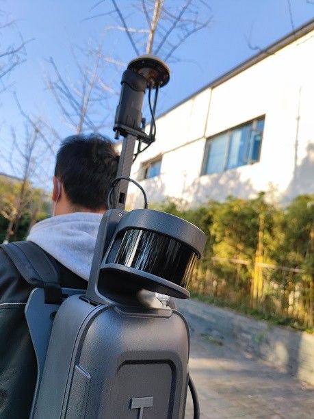
| Operation Mode: | Handheld/Backpack | Weight: | <2.5kg |
| Highlight: | Backpack 3D LiDAR HiSLAM,Handheld 3D LiDAR HiSLAM,120m Range HiSLAM |
||
120m range hand-held or backpack 3D LiDAR HiSLAM in building facade measurement
Building facade measurement is not only the core project of upgrading old buildings and building 3D model construction in digital city construction, but also the urgent demand for the protection of ancient buildings and the acquisition of facade results of new buildings (structures). At present, the difficulties of building facade measurement are mainly reflected in the following two points: first, building facade measurement requires a high degree of detail refinement; the shape feature points of buildings are numerous, the data acquisition is difficult, and the measurement efficiency is low. Second, the building facade measurement task is large and the time cycle is short. The traditional theodolite intersection method, total station prism-free measurement, rangefinder, steel ruler measurement and other building measurement methods have serious shortcomings of insufficient operation efficiency.
With the development of 3D laser scanner technology and the emergence of handheld 3D laser scanner based on SLAM technology, it brings new solutions for building facade measurement.With the characteristics of compact, portable and mobile scanning, it can effectively improve the scanning efficiency.
The process of building facade measurement based on HiSLAM includes three main steps: field survey, field data collection and internal data processing. High-precision 3D laser point cloud data of buildings can be obtained through HiSLAM field data acquisition operation, and then manual in-job mapping operation can quickly and efficiently obtain facade information.
Specification
| Items | Parameters |
| System Accuracy | ≤10cm(outdoor absolute accuracy) |
| ≤10cm(indoor relative accuracy) | |
| Measurement Range | 120m@20% |
| Scanning Point Frequency |
300,000points/s |
| Panoramic Camera | ≥12MP |
| Data Storage | 512GB SSD |
| Data Transmission | GigE/USB3.0 |
| Battery Life | ≥4h |
| Operation Temperature |
-10-50℃,humidity < 85% |
| Weight | <2.5KG(handheld host) |
| Operation Mode | Handheld/Backpack |
Advantages
1. Integration: highly integrated, indoor and outdoor integration
2. Calibration free: calibration is independent of the carrier
3. High accuracy: high point cloud density, high point recognition rate, high measurement accuracy
4. High reliability: high degree of productization, stable and reliable system
5. High intelligence: seamless integration of point cloud an panorama
Building facade measurement results with handheld 3D laser scanner based on SLAM technology
![]()
Contact Person: Mr. EPiC Team
Tel: +8618520517897