
Hi-Cloud, a leader of 3D laser scanning technology.
 |
| Place of Origin: | China |
| Brand Name: | Hi-Cloud |
| Certification: | ISO, others upon the requests |
| Model Number: | PM-1500 High Precision Airborne LiDAR System |
| Minimum Order Quantity: | 1 |
|---|---|
| Price: | Negotiable |
| Packaging Details: | Transport Case |
| Delivery Time: | 20-30 working days |
| Payment Terms: | T/T |
| Supply Ability: | 15 sets/month |
| Wave Band: | Near Infrared (Class 1 ) | PRR: | 100-2000Khz |
|---|---|---|---|
| Range: | 1500m@60% Reflectivity | Range Accuracy: | 5mm@50m |
| Angular Resolution: | 0.001° | FoV: | 75° |
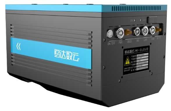
| Weight: | 4.4kg | Dimension: | 293×165×164mm |
| Highlight: | Drones airborne laser scanning lidar,100Khz airborne laser scanning lidar,Airborne Lidar Systems For Drones |
||
100-2000Khz PRR 1500m@60% range 5mm@50m accuracy PM-1500 Airborne LiDAR System with 0.001° angular resolution 75° FoV
PM-1500 high precision airborne LiDAR system is based on a new generation of core technology framework from Wuhan Hi-Cloud Technology Co.,Ltd. It is a newly launched airborne LiDAR with high point frequency, high scan frequency, high precision and tightly integration. The core component of the system is the laser scanner with multi-echo technology function which is independently developed by Hi-Cloud. It integrates modules like high-precision inertial navigation module and aerial survey camera. It is suitable for various carriers such as VTOL fixed wing UAV, multi rotor UAV and helicopter. Combined with professional post-processing software, an "end to end" solution will be offered to the customer to solve their problems and to fulfil tasks. It is widely used in survey grade mapping, topographic surveying and mapping, cadastral survey, traffic survey, power line inspection, forestry survey, disaster monitoring and other fields.
![]()
Specification
PM1500 High Precision Airborne LiDAR System
| Items | Parameters | |
| Laser Scanner | Laser Wavelength | Near Infrared (Class 1 ) |
| PRR | 100-2000kHz | |
| Maximal Measurement Range |
1500m@60% reflectivity 1000m@20% reflectivity |
|
| Range Accuracy | 5mm@50m | |
| Angular Resolution | 0.001° | |
| Scanning Speed | 40-400scans/sec | |
| FoV | 75° | |
| Camera | Resolution | 42.4M pixels |
| Focal length | 28mm | |
| POS(post-processing) | Positioning Accuracy | Horizontal 0.01m |
| Elevation0.02m | ||
| Orientation Accuracy | Heading 0.009° | |
| Pitch/roll 0.005° | ||
| System performance | Dimension | 293×165×164mm |
| Absolute | Horizontal ≤5cm | |
| Accuracy | Vertical ≤5cm | |
| Weight | 4.4 kg | |
| Multi-echo Technology | 4 times | |
| Temperature/Humidity | Operation:-40°C ~ 60°C Humidity 85% |
|
| Storage: -45°C ~ 70°C Humidity 85% |
||
System Advantages
Application Projects
1. Inspection of 500kV DC transmission line
The inspected line of the project is 500kV DC transmission line segment, including 3 base towers and 2 intervals, with a total length of about 0.8km.
The transmission line in this section is electrified, with undulating terrain, vegetation coverage, rich geomorphic types, good intervisibility between towers, and roads can reach below the towers.
Project Requirement: Danger point status analysis/Danger point predictive analysis/Component status quantitative analysis
The PM-1500 high precision airborne LiDAR system is used for data acquisition. DSM/DEM will be quickly generated for DLG and 3D model production.
![]()
![]()
2. Topographic Survey
The survey area is mainly flat terrain with small undulations and a maximum height difference of 20 meters. There is a main road in the survey area, with more vegetation and several densely populated areas.
Accuracy requirement: 1)The point density requirement is better than 16pt/m²; 2)Horizontal/vertical accuracy requirements: ≤5cm, meet 1:500 topographic surveying and mapping requirement
Project difficulties:
1) Complex terrain: The survey area has dense vegetation, and traditional surveying and mapping cannot efficiently obtain accurate elevation data in the survey area;
2) Tight time: It takes 3 days to complete the data collection and result data output of the survey area;
3) Difficult transportation: The road conditions in the survey area are complicated, and the transportation of traditional surveying and mapping equipment is time-consuming and laborious;
4) Epidemic: There are many residents in the village, and strict closed-off control management during the epidemic brought certain challenges to field data collection.
The main instruments and equipment invested in the project are the Hi-Cloud PM-1500 airborne LiDAR system, L150 multi-rotor UAV platform, Hi-Target IRTK2 receiver, and the urban off-road vehicle.
![]()
![]()
![]()
3. 3D City Model Project
The total area of the survey area is about 10 square kilometers. It is necessary to obtain the original laser point cloud and oblique image in the survey area, and generate the 3D model according to the obtained original data.
The laser point cloud obtained by airborne LiDAR aerial survey technology and the digital image data taken by oblique camera are used to generate Digital Elevation Model (DEM) and Digital Orthophoto Map (DOM) and produce terrain model. At the same time, the 3D model is generated based on laser point cloud data and line drawing.
Obtain the building height through the 3D model, obtain the building information through the oblique image and ground photos, and then build the building information database.
The project adopts PM-1500 LiDAR carried by UAV for measurement. Take off and landing points shall be located with wide vision and high altitude as far as possible.
![]()
![]()
![]()
![]()
Contact Person: Mr. EPiC Team
Tel: +8618520517897


