Hi-Cloud, a leader of 3D laser scanning technology.
 |
| Place of Origin: | China |
| Brand Name: | Hi-Cloud |
| Certification: | ISO, others upon the requests |
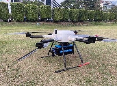
| Model Number: | High precision Airborne LiDAR System PM-1500 |
| Minimum Order Quantity: | 1 |
|---|---|
| Price: | Negotiable |
| Packaging Details: | Transport Case |
| Delivery Time: | 20-30 working days |
| Payment Terms: | T/T |
| Supply Ability: | 15 sets/month |
| Application: | Soil And Water Conservation | Range Accuracy: | 5mm@50m |
|---|---|---|---|
| Angular Resolution: | 0.001° | FoV: | 75° |
| Max. Range: | 1500m | Camera Resolution: | 42.4MP |
| Highlight: | 1500m Mobile LiDAR System,UAV Mobile LiDAR System,1500m UAV Lidar Sensor |
||
Accuracy 5mm@50m range 1500m high frequency 2000kHz 4.4kg airborne LiDAR System PM-1500 for soil and water conservation
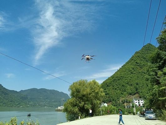
The goal of water and soil conservation is to prevent and control water and soil loss, protect, improve and make rational use of water and soil resources, maintain and improve land productivity, alleviate flood, drought and sandstorm disasters, give full play to the ecological benefits of water and soil resources and establish a good ecological environment. A typical feature of water and soil loss is the change of ground morphology, which is reflected in the obvious change of ground elevation value at the same position in the two periods of DEM data. 3D laser scanning technology can accurately represent the DEM form of slope land, which adds a new technical means to the application of soil and water conservation.
PM-1500 airborne LiDAR system can collect multi temporal laser point cloud data before and after water and soil loss changes, and generate high-precision DEM data through point cloud pre-processing. The comparison of DEM data between the two periods can better reflect the small change trend of soil and water loss, so as to provide an accurate basis for the protection of soil and water loss.
Specification
| Laser Scanner | Wave Band | Near Infrared (Class 1 ) |
| PRR | 100-2000Khz | |
| Maximum Measurement Range | 1000m@20% reflectivity | |
| 1500m@60% reflectivity | ||
| Range Accuracy | 5mm@50m | |
| Angular Resolution | 0.001° | |
| Scan Speed | 40-400 scans/s | |
| FoV | 75° |
| Camera | Camera Resolution | 42.4MP |
| Focal Length | 28mm |
| POS System | Position Accuracy(post-processing) | Horizontal 0.01m |
| Elevation 0.02m | ||
| Orientation Accuracy(post-processing) | Heading 0.009° | |
| Pitch/Roll 0.005° |
| System Performance | Dimension | 293×165×164mm |
| Absolute Accuracy | horizontal <5cm | |
| vertical <5cm | ||
| Weight | 4.4kg | |
| Multi Echo | 4 times | |
| Temperature and Humidity | Operation: -40℃~60℃, Humidity 85% | |
| Storage: -45℃~70℃, Humidity 85% |
1. Independently developed software to support one-stop data processing.
2. Ultra high frequency 2M points/s, more truly reflect the landform of the survey area.
3. Ultra long range 1500m, wider flight belt, can improve the point cloud acquisition efficiency.
4. High precision 5mm@50m, can meet requirements of various high-precision application scenarios.
5. Highly integrated and innovatively optimized system, stable and reliable, suitable for multi platforms.
Contact Person: Mr. EPiC Team
Tel: +8618520517897