Hi-Cloud, a leader of 3D laser scanning technology.
 |
| Place of Origin: | China |
| Brand Name: | Hi-Cloud |
| Certification: | ISO, others upon the requests |
| Model Number: | Highly Integrated HiScan-C Mobile LiDAR System |
| Minimum Order Quantity: | 1 |
|---|---|
| Price: | Negotiable |
| Packaging Details: | Transport Case |
| Delivery Time: | 20 working days |
| Payment Terms: | T/T |
| Supply Ability: | 5 sets/month |
| Application: | Tunnel Section Monitoring | Number Of Sacnners: | 1 Or 2 |
|---|---|---|---|
| Panorama Camera Resolution: | 30MP | Range Measurement: | 150m/300/600m@90% |
| Range Accuracy: | 5mm@40m | Scan Speed: | 200scans/s |
| Highlight: | HiScan-C LiDAR Land Surveying,mobile LiDAR Land Surveying,5mm@40m Deformation Monitoring System |
||
150m/300/600m@90% range 200scans/s speed 5mm@40m accuracy HiScan-C Mobile LiDAR System for tunnel section monitoring
Urban rail transit has brought great convenience to citizens, but with the growth of train operation time, the change of surrounding geological conditions, as well as the influence of adjacent engineering construction, will lead to tunnel track deformation and serious safety risks. However, the traditional tunnel monitoring method has low monitoring efficiency, low degree of automation, and consumes a lot of time and labor cost.
With the rise of 3D laser mobile measurement technology, it has the characteristics of high efficiency, non-contact and initiative. It can obtain high-precision and high-density point cloud data, and obtain high-quality tunnel section monitoring results through indoor processing. HiScan series 3D laser mobile measurement system can effectively solve the shortcomings of traditional monitoring methods, making tunnel monitoring more efficient and convenient.
Features
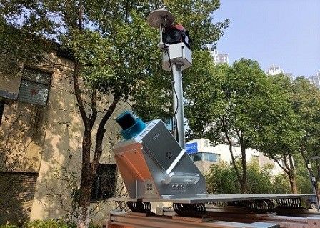
1. The self-developed new surveying and mapping equipment HiScan-C high-precision mobile LiDAR system has high degree of productization, stable and reliable system, and its data can be widely used in basic terrain surveying and mapping, urban special survey, traffic survey and design Internet street view map, 3D digital city and other fields.
2. With 5mm@40m high range accuracy, the system can be widely used in high-precision application fields such as street view map, basic terrain mapping, urban municipal component survey, traffic survey informatization, urban landscaping survey, digital / intelligent 3D City and so on.
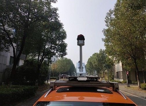
3. HiScan-C high-precision mobile LiDAR system can be easily installed on cars, ships or other mobile carriers, and has a million level laser emission frequency. During the high-speed movement of the carrier, it can collect high-density point cloud data and feed back the real information of ground objects.
4. HiScan-C high-precision mobile LiDAR system integrates sensors such as satellite positioning module (GNSS), inertial navigation unit (IMU), mileage encoder, 360° panoramic camera, assembly control module, and high-performance computers. Provide integrated solutions to meet the requirements of customers.
Parameters
| Type/Model | HiScan-C SU1 |
HiScan-C SU2 |
| Number of Sacnners | 1 | 2 |
| Range Measurement | 150m/300/600m@90% | 150m/300/600m@90% |
| Laser Frequency | Max. 500,000 points/s | Max. 1,000,000 points/s |
| Range Accuracy | 5mm@40m | 5mm@40m |
| Angular Measurement Resolution | 0.0088° | 0.0088° |
| Panorama Camera Resolution | 30M pixels | 30M pixels |
| Accuracy | 5cm@100m | 5cm@100m |
| Scan Speed | 200scans/s | 200scans/s |
| Weight | 13kg | 36kg |
Contact Person: Mr. EPiC Team
Tel: +8618520517897