Hi-Cloud, a leader of 3D laser scanning technology.
 |
| Place of Origin: | China |
| Brand Name: | Hi-Cloud |
| Certification: | ISO, others upon the requests |
| Model Number: | HS500i terrestrial laser scanner |
| Minimum Order Quantity: | 1 |
|---|---|
| Price: | Negotiable |
| Packaging Details: | Transport Case |
| Delivery Time: | 7 working days |
| Payment Terms: | T/T |
| Supply Ability: | 50 sets/month |
| Application: | Rural Housing Real Estate Registration | Ranging Mode: | Pulse |
|---|---|---|---|
| Max. Range: | 500m | Accuracy: | 5mm@40m |
| PRR: | Max. 500kHz | Angular Resolution: | 0.001° |
| Highlight: | 500m terrestrial 3d laser scanner,IP64 terrestrial 3d laser scanner,1.5m 3D Laser Scanner For Buildings |
||
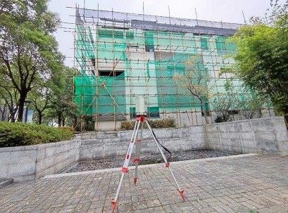
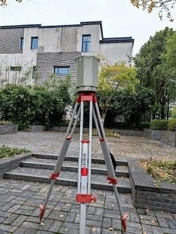
1.5m to 500m range 5mm@40m accuracy HS500i terrestrial laser scanner for rural housing real estate registration
Rural housing real estate registration is an important basic work for the country to deepen the reform of rural collective property rights system. The measurement result of integrated real estate is the basic data of rural real estate registration. How to quickly and effectively collect large-scale rural cadastral and housing data, improve the efficiency of rural real estate registration and reduce the cost of data collection is the mission and challenge of surveying and mapping geographic information industry.
HS500i high-precision 3D laser scanner is a pulsed, full waveform, high-precision and high-frequency 3D laser scanner independently developed by Hi-Cloud. The HS500i 3D laser scanner can generate 3D point cloud data, restore and display all parts and structures of the integrated elements of the real estate, and directly carry out drawing production on the point cloud data through professional software. This operation mode not only saves time and improves production efficiency, but also has lower requirements for professional skills of operators than traditional surveying and mapping methods. More importantly, by transforming a large number of field measurement work into indoor data acquisition and processing, it not only reduces the dependence of surveying and mapping work on weather, but also ensures the accuracy of surveying and mapping results.
Features:
1. PRR up to 500kHz
2. Measurement range from 1.5m to 500m
3. High precision 5mm@40m
4. Operation temperature -20℃~+60℃
5. Data storage 240GB(SSD)
Parameters:
| Laser Class | Class 1 (eye safe) | |
| Laser Beam Divergence | 0.35mrad | |
| Echo Mode | Full waveform, multi-echo technology | |
| Max. Range | 500m@90%,100kHz | |
| Range Accuracy | 5mm@40m | |
| Laser Pulse Repetition Rate PRR |
Max. 500kHz |
|
| Scan FoV | vertical | 100°(-40°~+60°) |
| horizontal | 360° | |
| Angular Measurement Resolution | vertical | 0.001° |
| horizontal | 0.001° | |
| Scan Speed | vertical | 3-150scans/s |
| horizontal | max.36°/s | |
| Dual-axis tilt sensor | Range | ±5° |
| Resolution | 0.001° | |
| Data Transmission | GigE/USB2.0 | |
| Control Mode | Support mobile terminal APP and remote control | |
| Communicate Interface | GigE/USB2.0/WLAN/Camera Trigger/GPS Synchronization,etc. | |
| Operation Temperature | -20℃~+60℃ | |
| Storage Temperature | -40℃~+85℃ | |
| Humidity | non condensing | |
| Protection Class | IP64 | |
| Main Dimensions |
φ188mm×318mm |
|
| Weight | ca.10.5Kg | |
Contact Person: Mr. EPiC Team
Tel: +8618520517897