Hi-Cloud, a leader of 3D laser scanning technology.
 |
| Place of Origin: | China |
| Brand Name: | Hi-Cloud |
| Certification: | ISO, others upon the requests |
| Model Number: | HiScan-C High Precision LiDAR Mobile Mapping System |
| Minimum Order Quantity: | 1 |
|---|---|
| Price: | Negotiable |
| Packaging Details: | Transport Case |
| Delivery Time: | 20 working days |
| Payment Terms: | T/T |
| Supply Ability: | 5 sets/month |
| Application: | Urban Construction And Planning | Laser Frequency: | 500,000 Points/s Or 1,000,000 Points/s |
|---|---|---|---|
| Range: | 150m/300/600m@90% | Accuracy: | 5mm@40m |
| Scan Speed: | 200scans/s | Number Of Sacnners: | 1 Or 2 |
| Highlight: | MMS Vehicle Mounted LiDAR System,HiScan-C Vehicle Mounted LiDAR System,MMS lidar radar mapping |
||
500,000 or 1,000,000 points/s frequency 5mm@40m accuracy HiScan-C LiDAR MMS for urban construction and planning
In recent years, with the development of 3D spatial information acquisition and application, it has been widely used in urban construction and planning. HiScan series 3D laser mobile measurement system can quickly, automatically and continuously obtain high-precision point cloud data. It is a popular application direction in the geographic information industry.
In urban construction and planning, using hiHiScan series 3D laser mobile measurement system can obtain a large number of urban block point cloud data, including a large number of urban components, vegetation, road markings, buildings and other point cloud data. Classifying and extracting these massive point cloud data can greatly improve the work efficiency of urban construction planning departments.
Advantages
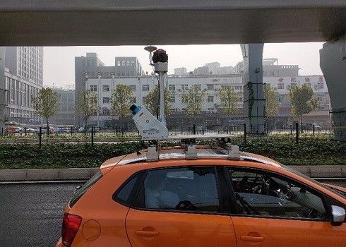
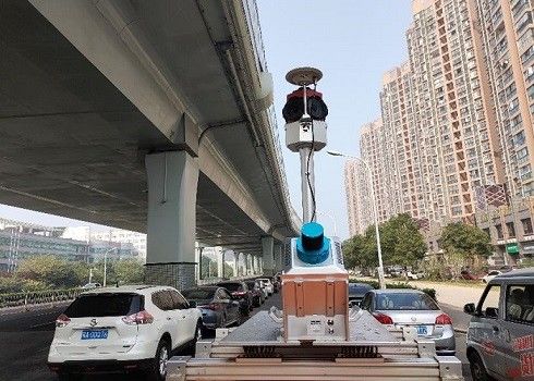
1. HiScan-c high-precision LiDAR mobile mapping system independently developed by Hi-Cloud can be easily installed on cars, ships or other mobile carriers.
2. The system has a million level laser emission frequency. During the high-speed movement of the carrier, it can collect high-density point cloud data and feed back the real information of ground objects.
3. The range accuracy of HiScan-C high-precision LiDAR mobile mapping system is 5mm@40m. It has ultra-high point cloud accuracy and more accurate point selection.
4. It can be widely used in high-precision application fields such as street view map, basic terrain mapping, urban municipal component survey, traffic survey informatization, urban landscaping survey, digital / intelligent 3D City and so on.
5. The whole system is highly integrated, and can provide an integrated solution for the whole life cycle operation process.
Parameters
| HiScan-C SU1 |
HiScan-C SU2 | |
| Number of Sacnners | 1 | 2 |
| Range Measurement | 150m/300/600m@90% | 150m/300/600m@90% |
| Laser Frequency | Max. 500,000 points/s | Max. 1,000,000 points/s |
| Range Accuracy | 5mm@40m | 5mm@40m |
| Angular Measurement Resolution | 0.0088° | 0.0088° |
| Panorama Camera Resolution | 30M pixels | 30M pixels |
| Accuracy | 5cm@100m | 5cm@100m |
| Scan Speed | 200scans/s | 200scans/s |
| Weight | 13kg | 36kg |
Contact Person: Mr. EPiC Team
Tel: +8618520517897