
Hi-Cloud, a leader of 3D laser scanning technology.
 |
| Place of Origin: | China |
| Brand Name: | Hi-Cloud |
| Certification: | ISO, others upon the requests |
| Model Number: | High Speed HiScan-C LiDAR Mobile Mapping System |
| Minimum Order Quantity: | 1 |
|---|---|
| Price: | Negotiable |
| Packaging Details: | Transport Case |
| Delivery Time: | 20 working days |
| Payment Terms: | T/T |
| Supply Ability: | 5 sets/month |
| Application: | Highway Slope Monitoring | Scan Speed: | 200scans/s |
|---|---|---|---|
| Range: | 150m/300/600m | Laser Frequency: | 500,000 Points/s Or 1,000,000 Points/s |
| Angular Resolution: | 0.0088° | Range Accuracy: | 5mm@40m |
| Highlight: | HiScan-C LiDAR Mapping Equipment,200scans/s LiDAR Mapping Equipment,HiScan-C laser scanning measurement systems |
||
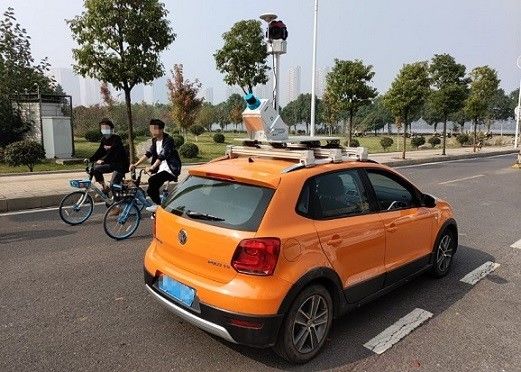
0.0088° angular resolution 5mm@40m accuracy 200scans/s HiScan-C LiDAR Mobile Mapping System for highway slope monitoring
The highway located in karst mountainous area is prone to deformation and landslide due to its fragile geological conditions, resulting in potential safety hazards to the passing vehicles. Therefore, in order to ensure the safety and stability in the process of highway construction and operation, it is necessary to monitor the highway and its affiliated structures. Among them, landslide monitoring on the slope along the highway is one of the most important work. The traditional landslide monitoring mainly depends on manual measuring points and topographic mapping, which has low efficiency, small data coverage and dangerous operation mode.
At present, HiScan series 3D laser mobile measurement system has been widely used in the monitoring of landslide, debris flow and other natural disasters because of its advantages of high efficiency, non-contact and rich data acquisition. The laser point cloud data obtained based on 3D laser scanning technology can be used to construct a refined 3D model, which can be used for landslide deformation element extraction and scene reconstruction analysis.
Features
1. Lightweight: small size and multiple carriers, greatly reducing the blind area of operation
2. Integration: highly integrated, integrated solution
3. High precision: high point cloud density, high point recognition rate, high measurement accuracy
4. Easy to operate: simple and convenient operation
5. Easy to store: pluggable data storage design
Specification
|
Type/Model |
HiScan-C SU1 |
HiScan-C SU2 |
| Number of Sacnners | 1 | 2 |
| Laser Frequency | Max. 500,000 points/s | Max. 1,000,000 points/s |
| Weight | 13kg | 36kg |
| Range Measurement |
150m/300/600m@90% |
|
| Range Accuracy | 5mm@40m | |
| Angular Measurement Resolution | 0.0088° | |
| Panorama Camera | Ladybug | |
| Panorama Camera Resolution | 30M pixels | |
| Accuracy | 5cm@100m | |
| Scan Speed | 200scans/s | |
Contact Person: Mr. EPiC Team
Tel: +8618520517897


